The flood described in Genesis was no mere storm. It was caused by catastrophic events which caused water to be released from beneath the earth while it also poured overhead.
In the six hundredth year of Noah’s life, on the seventeenth day of the second month—on that day all the springs of the great deep burst forth, and the floodgates of the heavens were opened. And rain fell on the earth forty days and forty nights.
Genesis 7:11-12
Implications of a Catastrophic Global Flood
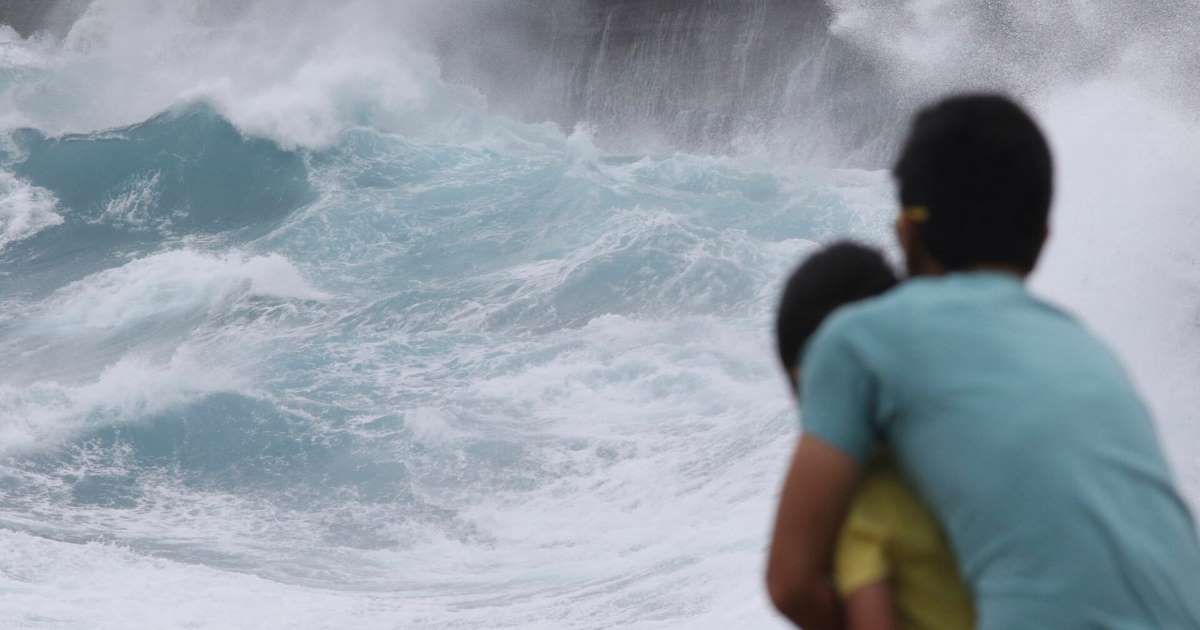
A catastrophic flood is just like it sounds. Catastrophic events like earthquakes, volcanic eruptions, and tsunamis began a chain of events that resulted in global flooding. A massive disturbance to the earth’s crust (as could occur with a large scale meteor impact) would result in reactive earthquakes, volcanic activity, and landslides. Underwater tectonic plate movement would then generate tsunamis with long-period waves which can reach staggering heights. The largest mega-tsunami ever recorded was in 1953 and towered at 1720 feet, or 524 meters. The force of these massive waves, with velocities of up to 700 km/hour, would deposit a tremendous amount of water onto the land, destroying everything in its path. It would also depositing marine life and saltwater deposits across the surface of the affected areas.
Earthquakes and volcanoes most commonly occur at the collision zone between tectonic plates with tectonic plate movement capable of triggering both. Volcanic eruptions, occurring both on land and beneath the ocean, would cause a variety of associated environmental hazards. These include lava flows, falling ash and projectiles, mudflows, and toxic gases. Further, volcanic activity would also trigger other natural hazardous events including local tsunamis, deformation of the landscape, tremor-provoked landslides or avalanches, and floods when lakes are breached or when streams and rivers are dammed.
Falling volcanic ash contains a mix of chemicals and micronutrients. Once in the ocean, it would trigger algae blooms and cause damaging changes to coral reefs causing a mass extinction of marine life in affected areas. Meanwhile, huge clouds of sulfate particles would be released into the upper atmosphere. Daylight would turn to darkness as these ash clouds obscure the sun. The sulfate particles would also reflect solar energy back into space causing a drop in temperatures capable of Ice Age glaciation. This darkness would be accompanied by rain and lightning caused by the condensation of released steam. This moisture mixed with noxious plume gases would produce volcanic acid rain (pH 2.5-5.0), which is composed of mostly hydrochloric acid (HCl) and sulfuric acid (H2SO4). (Much of this was observed in the 2018 eruption of Hawaii’s Kilauea volcano.)
As earthquakes split the earth’s crust, the geological uplifts would create mountains, canyons, gorges, seamounts, and ocean trenches. Liquefaction, which turns solid ground into a liquid-like state from ground vibration, would produce mudslides, debris flow, and underwater land slides. This crustal uplifting from tectonic plate movement, is capable of releasing groundwater from the earth’ crust. There is an estimated 6 quintillion (6,000,000,000,000,000,000) gallons of groundwater residing in our planet’s crust. This release would only compound the destruction and flooding that had already occurred. Geological Hazard and Disasters, Earthquake, Landslides and Sinkholes (geologyscience.com)
Still think a catastrophic global flood is impossible? Look at the evidence.
Evidence Supporting a Catastrophic Global Flood
- There is evidence of a prehistoric Mega-tsunami in the Indian Ocean resulting from a meteor impact. Scientists Debate Evidence of Ancient Megatsunami (nationalgeographic.com)
- Skeleton of a 50-foot-long fossilized whale discovered in Egypt’s Western Desert. Whale fossil found in Egyptian desert (nbcnews.com); Multiple whale skeletons discovered in Chilean desert. The mystery of the ancient whale fossils in Chile’s Atacama Desert offers clues on beached whales – Vox ; A rare whale fossil has been pulled from a Southern California backyard lodged in 1,000-pound rock. Slideshow: Rare whale fossil pulled from Southern California backyard | 89.3 KPCC (scpr.org);
- There are entire mountains (seamounts) and mountain ranges that lay submerged beneath the surface of our oceans. Satellites detect ‘thousands’ of new ocean-bottom mountains – BBC News
- Fish fossils found in the Himalayans. Climbers who have been to the top of Mount Everest brought back rocks in which the fossils of sea lilies were discovered. Why Are There Fish Fossils High Up In The Himalayas? | The Weather Channel – Articles from The Weather Channel | weather.com; Ocean fossils distributed widely across rock surfaces in the Transantarctic Mountains Scientists say ocean fossils found in mountains are cause for concern over future sea levels (phys.org)
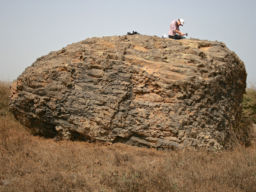
- Erratic boulders deposited at Cape Verde and Santiago Island, near the equator, were deposited a prehistoric tsunami. Huge erratic boulders in Tonga deposited by a prehistoric tsunami | Geology | GeoScienceWorld; Mysterious Boulders Suggest Ancient 800-Foot-Tall Tsunami – Eos
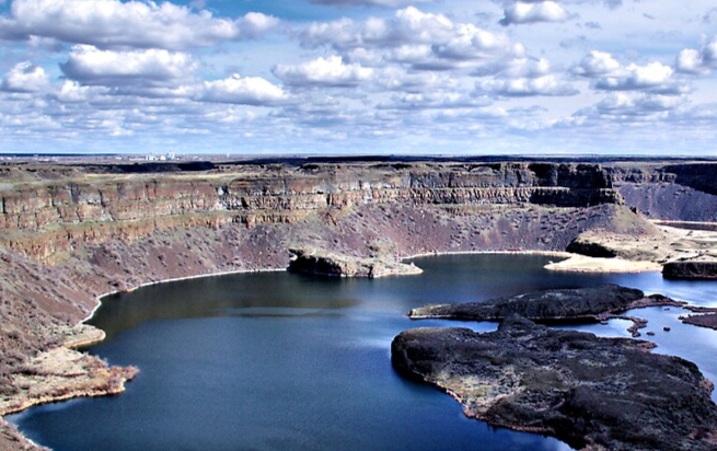
- Dry Falls at Grand Coulee in Washington state was carved by a prehistoric deluge of floodwaters, which formed a 3.5-mile wide and 400-foot tall waterfall. NASA – The Legacy of the Megaflood
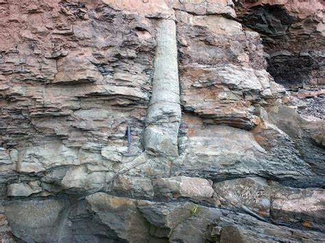
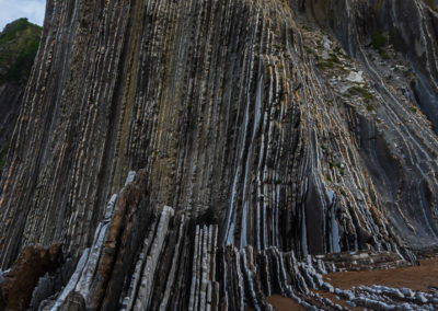
- “Fossil forests” have been found across the world including the eastern United States, eastern Canada, England, France, Germany, Australia, and Antarctica. These polystrate fossils stand vertically through multiple layers of horizontally deposited rock including sandstones, shales, and even coal seams. In Nova Scotia, erect trees and plants occur at over 50 “levels” scattered throughout 7,500 feet of rock layers. Drifted plants and trees also occur in many sections and are scattered over more than 10,000 vertical feet. These fossilized trees range from 2-15 feet in length, with the longest being 40 feet. The ‘Fossil Forests’ of Nova Scotia – How Old Are They Really? – Earth Age
- There are more than 833 million hectares of salt-affected soils around the globe (8.7% of the planet). Most of them can be found in naturally arid or semi-arid environments in Africa, Asia and Latin America. World map of salt-affected soils launched at virtual conference | Global Soil Partnership | Food and Agriculture Organization of the United Nations (fao.org)
- Flysch deposits found at the base of the Alps, Pyrenees, and Carpathian mountains. These are produced when a slurry of turbulent deep sea water and sediment are deposited to shallow-water shales and sandstones. These deposits are caused when a deep basin forms rapidly on the continental side of a mountain building episode, consistent with catastrophic flooding. Flysch – term, characteristics, weathering…… I Geotech doo I
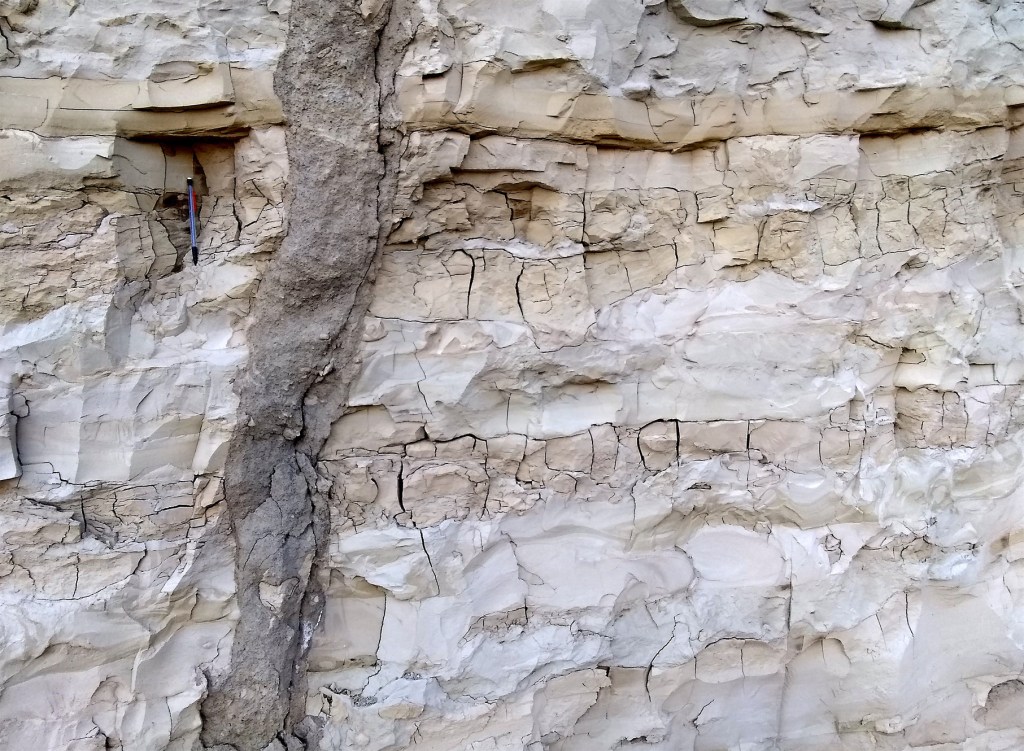
- Clastic Dykes are found worldwide. These occur when sedimentary rock is fractured and split open vertically. It is then filled with rapidly deposited debris flow as a result of liquefaction and is caused by events like earthquakes, meteorite impact, and destabilization due to storms. Clastic Dike – an overview | ScienceDirect Topics
- large-scale sedimentary processes (e.g., Jurassic Morrison Formation and associated rock units)
- global distribution of marine rocks (with extensive strata bearing marine fossils such as trilobites and ammonites)
- large scale volcanism (e.g., Deccan basalts, India; Columbia River basalts, NW US)
- Meteor impacts—more than 175 structures of possible extraterrestrial impact origin since the Precambrian, some of which measure up to 250-300 kilometers in diameter (e.g., Vredefort in South Africa, Chicxulub in Yucatan, Mexico).
Geoscience Research Institute | Catastrophic Earth Science: A Realistic Science (grisda.org)
The Question of Different Radiometric Dates
It’s true that very different radiometric dates have been ascribed to the events listed above. However, what is not clear is the accuracy of those dates. The reliability of radiometric dating is not in question; using the same sample at various labs is likely to yield very similar dates. The question is whether these dates represent the “true age” of the rock being measured. In theory, radiometric dating is accurate. But it also assumes a closed system, unaffected by environmental change, with a constant and consistent decay rate of the measured elements. This is something that is impossible to observe or verify, and very unlikely to be true. The concentration elements within a mineral is mobile, particularly uranium (U) and lead (Pb), which are prone to leaching. In fact, there are a variety of factors that can cause a mineral to “lie” about it’s age:
- Original Date is Unknown: In virtually every case, scientists do not know what the original condition of the rock was. Using the scale and continuing to trace backward, the method assumes a point in time when the concentration of these elements within the mineral was zero. This is both unlikely and unproveable. Without knowing the concentration of the original mineral this renders all “dates” derived from measurement geologically meaningless.
- Leaching and Mixing: Even if the original age of the rock had been known, it is not longer verifiable because of the environmental processes that occurred over time. Leaching can occur any time a rock sample was below the water table. For Uranium/Lead dating this means that some of the uranium that was initially present would be “leached” out of the rock. The uranium that has been released can then settle and recrystallize into other rocks that have little or no uranium in them. Surface weathering and exposure to the water table can have a tremendous impact on measured ages of ore sampling, even within the same area. Read more in research report by Dr. Andrew Snelling. Further, acid rain can dissolve many minerals that form sedimentary rock. The acid attacks carbonate (a common cement in sedimentary rocks) and feldspar, a principal ingredient of granite. This releases these minerals for settling into deeper levels of rock.
- Injection: Contamination of groundwater by injection of other elements, which results in distorted and inaccurate dating. Evidence for magmatic carbon bias in 14C dating of the Taupo and other major eruptions | Nature Communications
- Heat contamination: Two well-documented examples of “heat contamination” are the 1800 and 1801 eruptions from two Hawaiian volcanoes. Although these eruptions were less than 200 years old, the radiometric “dates” obtained from them were 140 million to 2.96 billion years for one, and from 0 to 29 million years for the other — depending upon the (ocean) depth at which the lava sample was obtained. Is Radiometric Dating Accurate? – Earth Age
I know I’m throwing a lot of science at you, but this is to demonstrate that we should not feel intimidated by the “established ages” assigned by radiometric dating. Like much of evolutionary theory, it is based on assumptions not fact. I have spent a tremendous amount of time to highlight the evidence in favor of a catastrophic global flood for one reason, to support that the word of God describes historical fact and is not a work of fiction. I encourage you to share this truth with all who are willing to listen. This truth has to be accepted if we hope to understand the events that are still to come.
As it was in the days of Noah, so it will be at the coming of the Son of Man. For in the days before the flood, people were eating and drinking, marrying and giving in marriage, up to the day Noah entered the ark; and they knew nothing about what would happen until the flood came and took them all away. That is how it will be at the coming of the Son of Man.
Matthew 24:37-39

Leave a comment